-
"الفلك الموضعي"
- مقدمة
- الكرة الأرضية
- هندسة المثلثات الكروية
- ملاحظات حول الهندسة الكروية
- إحداثيات أفقية "alt-az"
- إحداثيات استوائية "HA-dec"
- إحداثيات استوائية "RA-dec"
- الزمن النجمي
- الانتقال بين أفقي و استوائي
- إحداثيات مجرية
- إحداثيات بروجية
- الانتقال بين بروجي و استوائي
- حركة الشمس و ضبط الوقت
- القمر
- الإنكسار الجوي
- شروق و غروب الشمس، الشفق
- اختلاف المنظر المركزي اليومي
- اختلاف المنظر الموسمي
- الزيغ
- المبادرة و الترنح :اضطراب محور الأرض
- تقاويم
- الامتحان الأخير
- الإحداثيات الفلكية، خضر الأحمد
- الحركة الظاهرية للنجوم (تفاعلي)
- الأقطاب السماوية (تفاعلي)
الكرة الأرضية
سنبدأ بتعريف كرة مألوفة: الأرض (سنفترض مبدئياً أنها كروية), تدور حول محور .
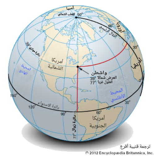 (الشكل-1) الإحداثيات الجغرافية الأرضية
القطبين الشمالي & الجنوبي هي النقاط التي تلتقي فيها هذه الأقطاب مع سطح الأرض. يقع خط الاستواء في منتصف المسافة بينهما.
خط الاستواء ما هو إلا مثال للدائرة الكبرى: و التي يمر مستويها بمركز الكرة. لكل دائرة كبرى قطبين. و يمكن تعريفها بهذين التعريفين: (a) هي النقاط على الكرة و التي تبعد عن دائرة بمقدار 90°. (b) هي النقاط التي يحددها الخط المعامد لمستوي الدائرة الكبرى و الذي يخترق سطح الكرة لتلك الدائرة. إن هذين التعريفين متكافئين.
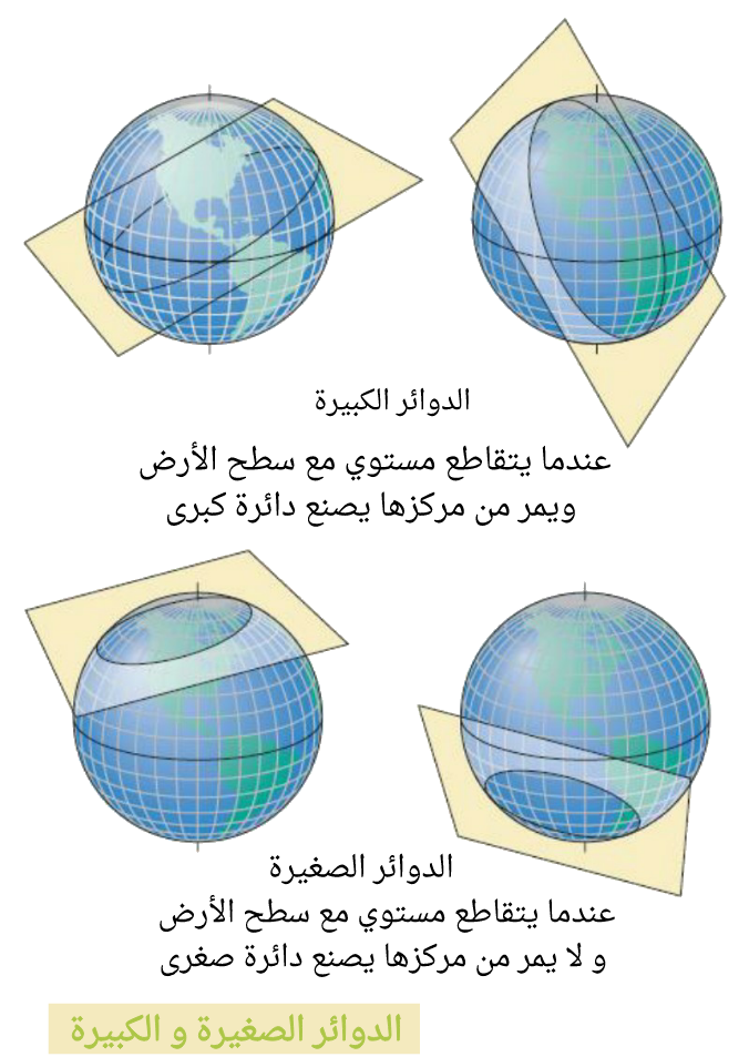 (الشكل-2) الدوائر الصغرى و الكبرى
 يعرف طول القوس للدائرة الكبرى على سطح الكرة بأنه الزاوية بين نقطتي نهايتيه، و ذلك كما يبدو من مركز الكرة، و يقدر بالدرجات ( لا يقاس بالأميال و لا بالكيلومتر ... إلخ).
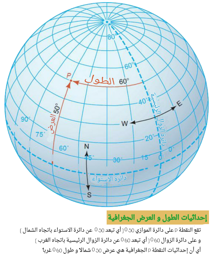
 (الشكل-3) الإحداثيات الجغرافية
 الدائرة الكبرى هي خط جيوديزي (و هو الخط الأقصر الواصل بين نقطتين) على سطح كرة و هو يماثل الخط المستقيم على سطح مستوي.
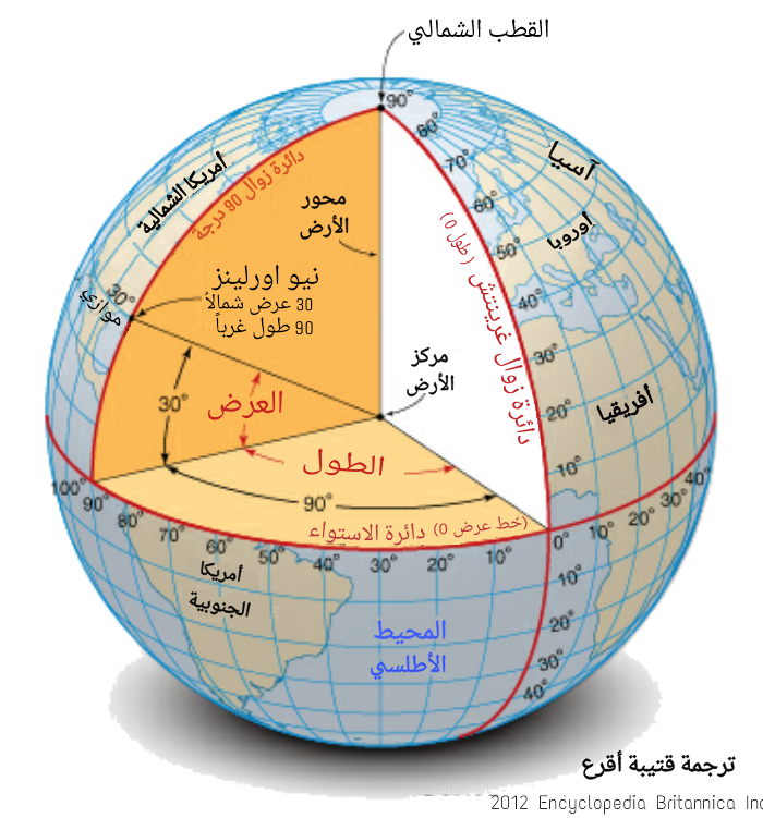
لوصف موضع نقطة X على سطح كرة الأرض، نستخدم العرض و الطول ( و هما إحداثيين اثنين، و يعود ذلك لكون سطح الكرة ثنائي البعد).
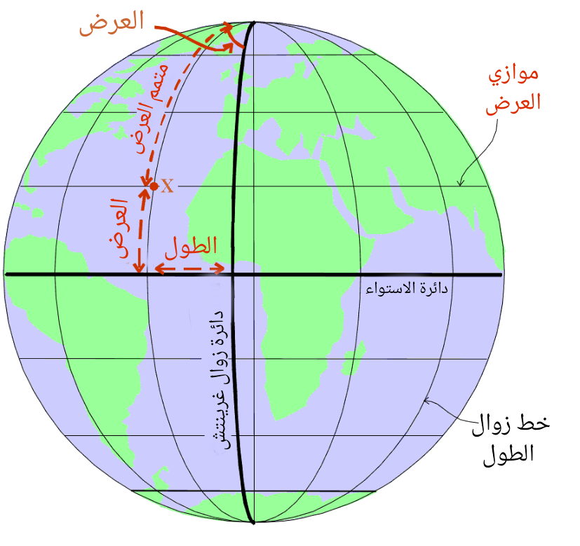 (الشكل-4) خط الزوال و خط الموازي
قم برسم دائرة كبرى من القطب إلى القطب بحيث تمر من الموضع X:و تدعى دائرة زوال الطول.
يعرف العرض Φللموضع X بأنه البعد الزاوي عبر خط الزوال هذا بدءا من دائرة الاستواء و حتى الموضع X, و يقاس من -90° للقطب الجنوبي و إلى +90° للقطب الشمالي.
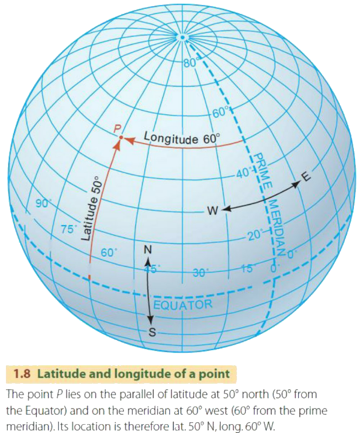
 (الشكل-5) توضيح معنى إحداثيات نقطة
يعرف متمم العرض للموضع X بأنه البعد الزاوي للنقطة X عن القطب الشمالي و تساوي
متمم العرض = 90° - العرض.
لا يوجد نقطة مميزة تعد مرجعاً قياسياً للطول ; و لاسباب تاريخية تم اختيار خط زوال يمر بمدينة غرينتش و هو خط الصفر المبدأ لخطوط الطول (و يدعى أيضاً خط الزوال الرئيسي).
 (الشكل-6) دوائر الطول و العرض على سطح الأرض
الطول λ للموضع X هو البعد الزاوي عبر دائرة الاستواء بدءاً من دائرة الزوال الرئيسية وصولاً إلى دائرة الزوال المارة بالموضع X. و تقاس شرقاً أو غرباً من قيمة 0° و حتى القيمة 360°, أو في كلا الاتجاهين من 0° و حتى 180°.
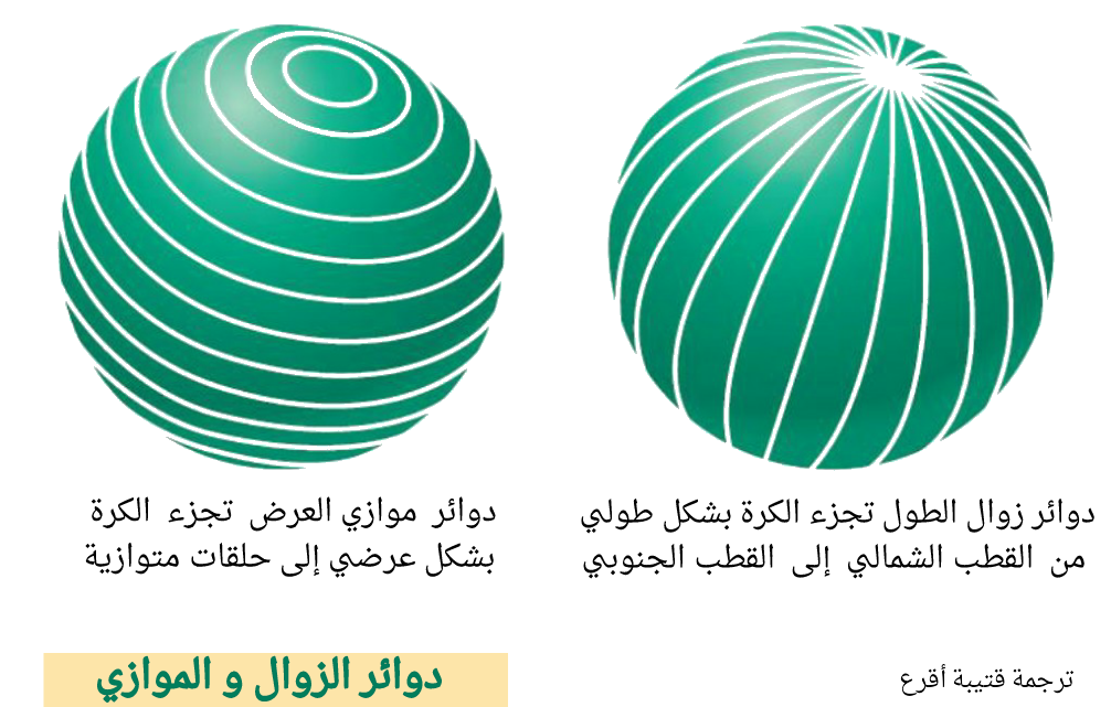
تدعى الدوائر الصغيرة الموازية لخط الاستواء موازيات العرض .
 (الشكل-7) دوائر الزوال و الموازي
 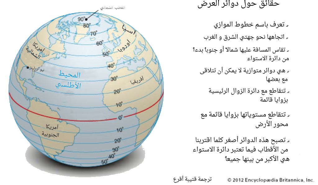 (الشكل-8) بعض الحقائق حول دوائر العرض
إن محيط أي دائرة خط عرض يساوي:
= 360 ✗ cos( مقدراً بالدرجات ( العرض.
يحسب طول القوس للدائرة الصغرى بين زوالين طوليين
= (الفرق في الطول) ✗ cos(العرض)
المسافة على الدائرة الكبرى هو دائماً أقل من هذا كما سنرى في القسم التالي.
تذكر بأن الموضع على سطح الأرض ثابت بالعودة الى استخدام دائرة رئيسية واحدة (دائرة الاستواء) و عليه تتوضع نقطة ثابتة واحدة (و هي نقطة تقاطعه مع زوال خط غرينتش).
الملاحة السماوية تستخدم في الإبحار( و كذلك في الملاحة الجوية) حيث تستخدم الهندسة الكروية, و تكون النتائج بقيم زاوية ( درجات). و يجب القيام بتحويل هذه القيم إلى قيم خطية للاستخدام العملي. و يعرف الميل البحري بأنه يساوي دقيقة-قوسية واحدة على طول الدائرة الكبرى على الأرض. و هذا يعطي زيادة 15% عن القيمة العادية "القانونية" للميل (6080 قدم بدلاً من 5280 قدم).
تمرين:
Alderney, هي مدينة في جزر الشانيل تقع على
خط طول 2°W و خط عرض 50°N.
Winnipeg, مدينة كندية, تقع على
خط طول 97°W و خط عرض 50°N
كم تبلغ المسافة بينهما مقدرة بالميل البحري, على امتداد خط العرض الموازي؟
الحل
ملاحظة: الاحداثيات الأرضية هي أكثر تعقيداً في الواقع من هذه التعاريف, و ذلك يعود لكون الأرض ليست كروية تماماً. و يمكنك الرجوع لهذه الروابط من أجل المزيد حول Ordnance Survey's:
- المقدمة
-
ترجمة قتيبة أقرع
- هندسة المثلثات الكروية
 (Figure-1) Geographical coordinates
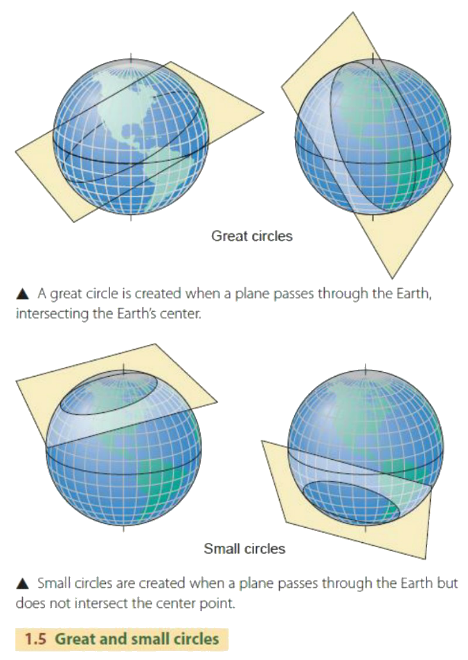 (Figure-2) Great and Small Circles
 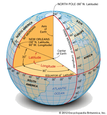 (Figure-3) Geographical Coordinates
 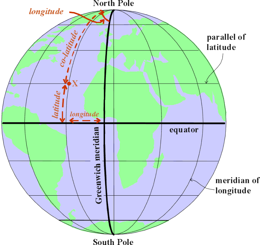 (Figure-4) Meridian and the parallel of Latitude
 (Figure-5) Coordinates of Point on the earth surface
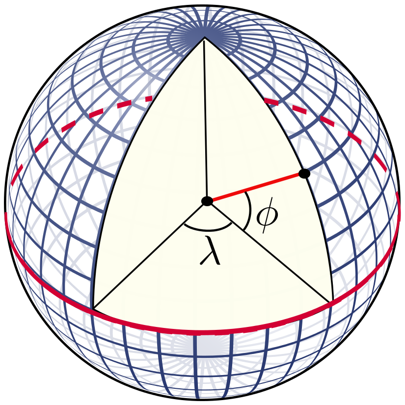 (Figure-6) Longitude & Latitude Circles
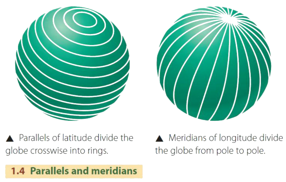 (Figure-7) Meridian & Parallel Circles
 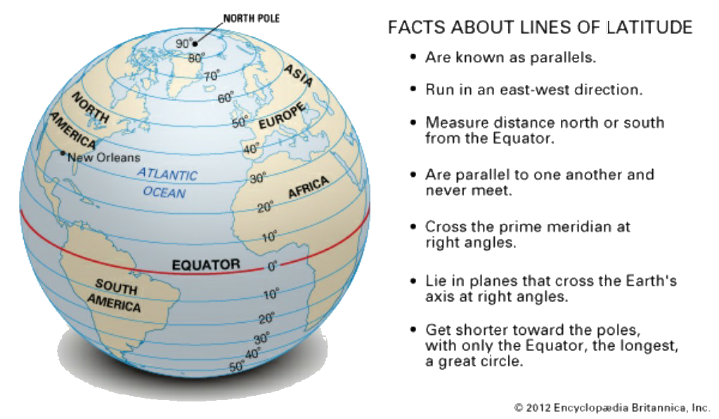 (Figure-8) facts about Latitude Lines